A Quarter Century In the Making: Selectmen OK Recommended Community Path

Photo: Chris Leino, chair of the Community Path Implementation Advisory Committee.

After more than a quarter century since the idea was first introduced, the concept of a pedestrian and bike path running through the town took a major step forward as the Belmont Board of Selectmen voted unanimously to recommend a proposed $27.9 million route advanced by the five-member Community Path Implementation Advisory Committee at the board’s meeting held Monday, Dec. 4 at Town Hall. 

“In my view, this is really an amazing opportunity for Belmont. I think the community path if constructed would be a fantastic crown jewel for [the town] … and an amazing resource for Belmont and surrounding communities,” said Russell Leino, chair of the Advisory Committee which spent nearly three years both devising a process and then leading a year-long feasibility study which analyzed countless byways which would connect Belmont with a proposed 104-mile Mass Central Rail Trail running from Boston to Northampton.

“This is the path we need to endorse,” said Selectman Mark Paolillo, the committee’s liaison to the committee.

“It has gone through endless public meetings, a significant amount of input from all stakeholders … we have reached an answer that this board needs to support as a way forward,” said Paolillo. 

The unanimity of support from the town’s executives was the validation Leino was seeking as the project now moves forward to the critical funding phase. 

“I’m really excited because this is an important step forward for this project. [T]his vote is really the end of the beginning and now we need to move forward on both funding and construction,” Leino told the Belmontonian after the meeting.

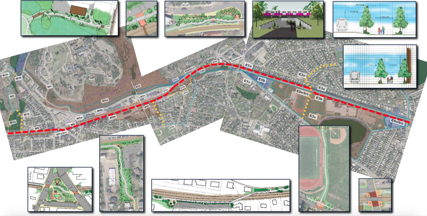
The committee’s timeline for the roughly two-mile project includes funding for preliminary and final design in 2018, secure construction funds from state and federal agencies by 2019 and construction in 2020 and 2021.

The suggested route – running from the Waltham line outside Waverley Square and connecting to an existing travel path at the Cambridge border – was not a surprise as it was unveiled early in November during the final meeting of the 10-step feasibility study process run by PARE Consulting that spent more than a year conducting meetings, walking tours and public forums.

“Our consultant [PARE’s Amy Archer] did an incredible job. Her comprehensiveness and demeanor was exceptional and made the process successful because she was so good at engaging the public and listening to feedback and reacting to it in a calm and reflective way,” Leino told the Belmontonian. 

“There weren’t any knee-jerk decisions and the way the [recommended] path [was evaluated] was done in a very deliberative way by going over the criteria over and over again,” said Paolillo.

Selectman Adam Dash successfully proposed adding language in the declaration that will allow the board and town to “tweak” the recommended path when the project encounters “the inevitable” unexpected delays and possible disputes with landowners.

One area that will need to be negotiated is in Waverley Square where developer Joseph DiStefano is proposing constructing commercial space along Trapelo Road – to be revealed in the first quarter of 2018 – that will be adjacent to the bike path. DiStefano, who attended Monday’s meeting, said he is willing to begin discussions with the town on accommodating each other’s interest.

Three Routes Presented As Finalists for Belmont’s Community Path

Photo: Screenshot of the presentation from Pare Corp of one of the three top-ranking routes.

And now there are three.

After more than a half a year of analysis and study, the project management team conducting a feasibility study of a community path in Belmont presented to the public three possible routes that “scored” the highest.

“It was listening to the public and performing a great amount of analysis to come up with the highest ranking routes,” said Amy Archer of Pare Corp. who presented the top three trails to about 70 residents who braved a windy, rainy Wednesday night, April 26 to attend the ninth public meeting held by the firm.

Archer said Pare will return in June to present its recommended route to the Belmont Board of Selectmen which will either accept, reject or ask for more options. If it approves the route, the path could be completed by the fall of 2021.

The feasibility study was approved by Town Meeting in May 2016 to recommend a single route that would best serve residents and function as a segment of the Mass Central Rail Trail, a proposed 104-mile rail trail from Northampton to Boston that can be used by bicyclists, walkers, runners, and nature enthusiasts.

In the previous eight meetings, the study explored the dozens of segments of a possible route, graded each using criteria based on engineering standards, cost and comments from the community on what it wanted the path to be. The firm also rejected proposed spans determined “fatally flawed” due to high cost or chronic safety issues.

The three selected routes are similar regarding length – about two miles long – and in the “score” each achieved: the best option with a score of 76 would cost $27.9 million, the second and third – both with scores of 75 – are priced at $31.8 million and $25.1 million.

Each route travels along the northern edge of the commuter rail from Belmont Center to a proposed pedestrian tunnel at Alexandra Avenue where the paths then travel along the south side of the tracks adjacent Belmont High School.

Archer said diverting the paths to the southside rather than continue on land owned by the Belmont Community Forum takes the paths away from the majority of Channing Road homeowners who have long opposed a path adjacent to their property lines. The southside also has the option of not being “squeezed” at its end at the crossing at Brighton Street at the FE French Building.

A major issue confronting the path transversing the southside of the commuter tracks is it will be in the same location as the site of a proposed renovated/new Belmont High School and encroaches on the property of Crate Escape, the dog daycare business at the corner of Brighton.

Archer said talks are ongoing concerning the high school property. Also, the portion of the Crate Escape property that would be used by the path is the loading dock, which is not essential for the business.

The three paths are quite similar traveling from Waverley to Belmont Center, staying on the north side of Pleasant Street. The primary difference is how the trail transverses the Waverley Square Center and the commuter rail station. The higher cost options rely on covering the opening over the location and building walls to support the new construction as opposed to using ramps.

The relatively good news for Belmont is that Archer anticipates that the entire project will be “fully funded” by grants from the Massachusetts Department of Transportation and the MBTA, in part, to the popularity of rail trail projects and that Belmont is a significant segment connecting two sections of the Mass Central Rail Trail.

Any of the paths would most likely qualify for funding if the were direct route and one supported by local officials, noted Archer.

Money could also be coming from the MBTA, according to Community Path Implementation Advisory Committee member Vincent Stanton, as the path would solve a “big problem the MBTA is facing” with making the Waverley Station handicap compliant with the installation of a ramp system that would be part of the community path.

But  the town will be required to pony up “a substantial amount”  for the initial design stage which will cost just under 10 percent of the total cost or about $2 million, funding that could be obtained through grants from the town’s Community Preservation Act account, a request for capital funds, a state legislative earmark, private funds or any combination.

If the route is accepted, it will take nearly four years from the point the design of the path begins to a grand opening, with the final two years the construction phase.

Wednesday’s Comm. Path Feasibility Meeting: $ and Rating the Routes

Photo: Community path in Somerville.

The penultimate public meeting of the Belmont Community Path feasibility study will finally focus on how much each of the possible routes running across Belmont will cost and how to find the Benjamins to pay for it.

The meeting, at 7 p.m., Wednesday, April 26, in the Chenery Middle School’s auditorium, will feature the work of Pare Corporation, the firm hired last year by the Belmont Board of Selectmen to be the study’s project manager. 

Wednesday’s gathering – dubbed “Hot Topics” by Pare – is the final public meeting before Pare presents its recommended path route to the Board of Selectmen in May. 

Wednesday’s event, the ninth feasibility study public meeting held by Pare, will focus on presenting four major components in evaluating and analyzing the routes that transverse the town from the Waltham border outside of Waverley Square to the Cambridge city line just off Brighton Street at the Fitchburg Cutoff Bikepath.

The night’s agenda includes:
        • The “Full” Matrix,
        • The study’s evaluation criteria,
        • Cost summaries for the route options, and 
        • Potential funding sources.

Pare will present what it is calling “the Full Matrix”, which is a spreadsheet in which each of the more than two dozen paths evaluated are ranked on a series of criteria, i.e. user experience, design attributes, cost, to determine the suitability of each route.

Community Path Feasibility Study Winding Down, Recommendation in April

Photo: Anne Archer of PARE Corporation leads residents in the latest round of the Community Path Feasibility Study on Wednesday, March 8.

Before approximately 50 residents in the Belmont Town Hall auditorium on Wednesday, March 8, the consultants conducting the feasibility study on a proposed multi-use community path running through Belmont said the review is “winding down” with a final recommendation from the team coming in about six weeks time.

PARE Corporation‘s Amy Archer and Kathleen Fasser, a ‎Principal at K3 Landscape Architecture,  unveiled several routes and their estimated costs associated with the third segment of the trail which runs from the commuter rail bridge in Belmont Center to Brighton Street adjacent to the Cambridge city line.

Information on the trail and costs have been placed in the Town of Belmont website. Questions and comments made up the remainder of the night. 

Archer said a final public meeting would be held in the next weeks to go over “hot topics” – issues such as privacy and public safety – which produced the most comments or raised matters in the previous three meetings.

Archer added the review team would include comments and suggestions into a recommendation report presented to the Board of Selectmen sometime in mid-to-late April, between town elections on April 4 and the first day of Town Meeting on May 1. 

“It will take about a month to incorporate what the community tells us is important to them into the final report,” she told the Belmontonian. 

Hired last year by the Community Path Implementation Advisory Committee, PARE will recommend to the town a single route that, according to the firm, will “best serve the Town’s residents AND function as a segment of the Mass Central Rail Trail.” 

The MCRT is a 104-mile former railroad line from Northampton to Boston that is being restored as a rail trail, a path to be used by bicyclists, walkers, runners, baby strollers and young cyclists with training wheels, wheel chair users, cross-country skiers, equestrians (in areas out west) and nature enthusiasts.

Community Path’s ‘Hot’ Topics at Wednesday’s Meeting

Photo: A previous public meeting of the Community Path Implementation committee.

“Hot topics” raised at three previous community meetings will return for a second go-around before residents as the Community Path Implementation Advisory Committee holds its fourth public meeting on the creation of a multi-use route through Belmont.

The meeting takes place on Wednesday, Dec. 7 at 7 p.m. at the Chenery Middle School, 90 School St.

The night will focus on discussing the major issues – such as privacy, on- and off-road path and alternative routes – with the committee’s engineering and landscaping consultants who are creating a feasibility study of the pathway.

The consultants, lead by Foxboro-based Pare Corp., will take data and information from the meeting and incorporate it into a matrix which will evaluate the various alternative routes.

“All views and comments made during the meeting will be reviewed and considered to the maximum extent possible,” said the committee in its agenda.

Five ‘Eastern’ Options Put Forth in Community Path Feasibility Study

Photo: Participants at last week’s community path feasibility study view alternative routes on poster boards.

The one message the consultants conducting the Belmont Community Path Feasibility Study wanted to convey to residents attending last week’s public meeting on building a path through Belmont was that any discussion would stay within the bounds of “respectful civil discourse.”

The need for such a reminder came as the study ventured into the proposed path’s most contentious “eastern” section from Belmont Center to Brighton Street. For the past three decades, Channing Road homeowners whose property lines have abutted a strip of land adjacent the MBTA’s commuter rail line have resisted calls from the bike and recreational campaigners who have sought to build a community path along the route.

And it turned out that just a few sparks from the approximately 60 residents who turned up to the Chenery Middle School auditorium. Rather, the public was more interested in what was being presented than debating the plans … just yet.

“[The study] is a collaboration” of all residents and interest groups, said Kathleen Fasser, ‎principal at K3 Landscape Architecture in Concord which is working with Pare Corp., hired by the town to conduct the feasibility study.

img_1192

Pare Corp’s Amy Archer.

Under the firm and business-like leadership of Pare’s Chief Planner Amy Archer, the consulting team revealed five alternatives routes:

  • Running on mostly land owned by the Belmont Citizens Forum along the north side of the MBTA commuter line tracks,
  • On the south side of the MBTA commuter line, hugging the back of Belmont High School.
  • A path in a “linear park” on a redesigned Concord Avenue,
  • One that meanders through the Belmont High property midway between C0ncord Avenue and the tracks, and
  • Using public roads in the Winn Brook neighborhood.

A detailed map and description of the five routes can be viewed in the feasibility study here.

You can see the path options for the western end of the route – from the Waltham line to the Department of Public Works site – here and the central section from the DPW to the commuter bridge in Belmont Center here.

Underpass in the mix

The study also includes several design plans for an underpass running about 50 feet from the end of Alexander Avenue under the commuter rail tracks and onto school property near Harris Field and the JV baseball diamond.

The pedestrian tunnel, first proposed and supported by town officials in the 1970s, would allow for a direct link from the Winn Brook neighborhood to community areas such as the high school and its playing fields, the Underwood Pools, the skating rink, the library and the Wellington Elementary School.

Archer also presented three crossing designs at Brighton Road – where a new path will likely cross the commuter rail tracks to meet an existing bike route that runs to Alewife MBTA station – that includes a pair of pedestrian bridges that would be well above the roadway and require long ramps on both sides of Brighton.

After presenting the five options, Archer said each path alternative was ranked and evaluated after a series of public engagements that included public meetings and two site visits in which the public and engineers walked the proposed paths.

Archer said the team had surveyed residents with 40 to 45 questions on what’s the most important feature of the roadway. While not a single feature rose to the top, a pair – that the path makes community connections and it brings high-quality recreation to the town – were on 70 percent of the surveys.

Archer pointed out that one important measure that has not been included in the calculations is the cost estimate for each route. But that was deliberate since the consultants wanted to determine town stakeholders’ preferences absent a bill in hand.

Public responses to the routes included questions and comments concerning the contentious issue from the previous public meeting that focused on how community path users would transverse Concord Avenue at the commuter rail bridge entering Belmont Center.

Sue Bass of upper Concord Avenue felt that attempting to add pedestrians and bike riders onto the current “free-for-all” of vehicle traffic at the tunnel “would kill people.”

Archer acknowledged that difficulty, pondering if a solution such as traffic lights or a traffic circle – called a “roundabout” – could be attempted.

“We are dying to do a traffic study there,” said Archer.

Other comments focused on whether to invest in snow removal equipment for the path or make it a nine months facility, the issue of people driving to the route and parking along residential streets and the danger of placing a path that intersects with side streets.

Next up on the schedule will be the final public meeting during the initial stage which will focus on “Hot Topics” – issues raised during the three previous gatherings – on Wednesday, Dec. 7 at 7 p.m. at the Chenery Middle School.

Take a Hike: Western Community Path Trail Walk Saturday Morning

Photo: Star Market parking lot.

Up until now, the many and varied routes that could make up a community path running the length of Belmont have been conceptional, drawn on a map or written in a report.

This weekend, residents will have the opportunity to discover exactly how those courses would ramble through town as the Community Path Implementation Advisory Committee invites the public to take a Saturday morning hike on the first of two Feasibility Study trail walks led by members of Pare Corporation, the Community Path’s consultant.

Saturday’s walk will encompass the western end of the path – Belmont Center to Waverley Square – Oct. 15, at 9 a.m. beginning at the Star Market parking lot. Boots and long pants are advisable.

Town Selects Firm for Community Path Feasibility Study, Set to Sign Contract

Photo: The East Bay Bike Path from Bristol to Providence, RI, created by the PARE Corp.

The long-awaited feasibility study to recommend a preferred route for a two-and-a-quarter mile long community path running through Belmont appears well on its way to becoming a reality. PARE Corp., the firm selected by both the Board of Selectmen and an advisory group to perform the study, has met a critical contract demand.

“There are only have a few things left to work out,” said David Kale, Belmont Town Administrator at an early morning Selectmen’s meeting on Tuesday, May 31, after announcing that PARE’s bid price for the study was below the $200,000 limit placed on the job by Belmont Town Meeting last year.

Kale also announced Tuesday the town will receive $100,000 from the state’s Department of Conservation and Recreation to assist in paying for the study, funds secured by Belmont State Rep. Dave Rogers. That will be added to the $100,000 in Capital Budget funds allocated by Town Meeting in June 2015 to be used by the end of fiscal year on June, 31.

When asked when a contract for the feasibility study could be signed, Kale would only say “soon.”

After obtaining six formal bids during the Request for Proposal process, PARE, with locations in Foxboro and Lincoln, RI, was the first choice of the Selectmen and the Community Path Implementation Advisory Committee, which has spent the past 18 months reviewing years of studies and analysis.

PARE was the one firm which has a background in studying and creating bike and community paths.

The feasibility study, which has a completion date of Dec. 31, 2016, will provide an overall cost for a path and a recommendation of the most efficient route from Waltham to Cambridge. The firm and town has committed to several public meetings and visits to the site during the feasibility work.

Selectmen OKs Feasibility Study for Proposed Community Path

Photo: Russell Leino (center), chair of the Community Path Implementation Advisory Committee with Heather Ivestor (left) and Brian Burke.

The Belmont Board of Selectmen took a significant step in moving the idea of a town community path towards reality when it approved the hiring an engineering consultant to create a feasibility study of a dozen proposed routes from the Waltham line to the Alewife bike path off of Brighton Street.

“Once [the Selectmen] makes a decision, we can make this happen,” said Russell Leino, chair of the Community Path Implementation Advisory Committee, which is overseeing the process for the town.

“Let’s get going with a [request for proposal] and move forward,” said Selectman Mark Paolillo, after hearing from the Community Path Implementation Advisory Committee at its meeting Monday, Dec. 15 at Town Hall.

Bowing to residents along Channing Road whose south-lying properties abut a favorite proposed path, the selectmen approved a suggestion by Selectmen Chair Sami Baghdady to have an additional route, traveling along a portion of Concord Avenue, added to the list of reviewed paths.

In his presentation, Leino said the guiding principle of the five-member group is not to “reinvent the wheel” instead build on the work of its predecessor, the Community Path Advisory Committee, which did the heavy lifting of carving out the possible routes through town.

The five-member Implementation Advisory Committee (Leino, Vincent Stanton, Heather Ivestor, Michael Cicalese and Brian Burke) was created a year ago to develop recommended strategies for the design, construction and implementation of community path route options selected by the Selectmen, “diving deep” into the routes recommended by CPAC, focusing on any choke points including rough terrain or intersections on busy roadways.

In addition to the pathway, the committee looked into an underpass from Alexander Avenue to the south side of the commuter rail tracks that would allow residents and students transverse from the Winn Brook neighborhood to Belmont High School safely. 

After spending a great deal of time adhering to the mandate, “we are now at the stage to put pen to paper” by moving to a feasibility study,” said Leino.

During the initial process, the study will help determine “what things did we missed? What are things that CPAC missed? Are there alternatives that we should be thinking of?” said Leino. 

With the Selectmen’s approval in hand, a draft request for proposal (RFP) will be put out to bid in early January. Leino expects to hire a firm in late spring and have a completed feasibility study by the end of 2016. A group will decide on a final recommended route that will be sent to the Selectmen in the Spring of 2017.

The $100,000 to hire the engineering consultancy comes from a grant from the Community Preservation Committee that was approved by the 2015 Town Meeting.

In addition to the CPC funds, the Massachusetts legislature approved a $100,000 earmark that would pay for a study. If Gov. Baker releases the funding – no small feat in this time of fiscal restraint – the state money could replace or, supplement the town’s funds.

According to Leino, once the final route has been selected, the committee can then focus on funding a project, which could be the least difficult portion of the project. A Belmont community path is in line for both national and federal grants that would pay for nearly 90 percent of the total cost of approximately $10 million for the 2.2-mile route. 

Leino said because Belmont is a significant link to an extensive bike path from Somerville to Berlin, Mass and will lie close to other popular community routes nearby in Cambridge, Watertown, and Arlington, “we’d be right up there in priority for funding.”

The federal and state money would be available once the town invests about $1 million into the trail as they “want us to have some skin in the game,” said Leino.

Despite that the feasibility study is more than a year away, there is pushback from residents in two neighborhoods – Channing Road and homes on Clark Lane adjacent to Clark Road – to the path’s proximity to the property lines and the chance that homeowners on Clark Lane and the Boston Housing Authority could lose a portion of their land to the path.

Baghdady’s request for the feasibility study to look into using Concord Avenue and School Department land at Belmont High School came after some Channing Road residents felt the Community Path Advisory Committee did not give that proposal enough consideration.

Leino said that the Advisory Committee found the Concord Avenue route was “impractical” for several reasons including busy intersections, traffic, active driveways and other impediments. Also, a Concord Avenue route would effectively end financing plans for an underpass at Alexander Avenue, said Paolillo. 

But Baghdady did not see an additional route as overburdening the feasibility study.

“The objective is to have a community path and to me, the more options we have before us, the better decision we can make,” said Baghdady, winning the argument. 

Belmont Selectmen Appoints Community Path Implementation Committee

The Belmont Board of Selectmen selected five residents – each with their specific skill set – to determine not just the best route for a community path to transverse Belmont, but also how to pay for it.

The Community Path Implementation Advisory Committee takes over from the Community Path Advisory Committee which completed its work in May after it researching and then developing a number of possibly combined bike/walking routes from Waltham to Cambridge.

“The desired outcome of this entire process is to have the community path built,” said Andy Rojas.

“The ultimate intent isn’t for a study … it’s for a physical path to be built that services the town and mitigates the negative and highlights all the positive impacts,” said Rojas.

The residents appointed to the committee are:

  • Brian Burke
  • Michael Cicalese
  • Heather Ivester
  • Russell Leino
  • Vincent Stanton

Each member comes with work experience or involvement with the proposed community path in the past. Burke was a member of the CPAC and will bring continuity to the process. Cicalese was selected to raise residents’ concerns to the group as a likely route will impact the Channing Road neighborhood. Ivester is a state licensed structural engineer while Leino is an attorney.

Stanton, who Selectman Mark Paolillo noted has been responsible for extending Belmont Town Meeting nights with his array of knowledgeable quires, is well-known in town for his divergent thinking and novel ideas and solutions to any number of issues facing the community.

The committee’s charge from the selectmen is to come to a consensus on the best path but also to uncover outside funding – be it private or from the state or federal governments – to pay for a good portion of the trail and also the evaluation and analysis of the potential of a proposed project.

“It’s pretty clear that this body needs to commit some how … identify public sources of funding to do a feasibility study,” said Rojas.

“We can then pursue other government grants for the implementation, but we need that feasibility study in hand,” he added.

According to several members of a pro-community path group that Paolillo noted at the meeting, “with a feasibility component, there could be significant funds from the state level for a path.”

The study will also provide the Selectmen – who will make the final decision on the route and if the project will move forward – the economics of building specific routes through Belmont.

“While not set in stone, that we would expect the feasibility study would give us input on the route options before we make up our minds,” said Rojas.