Updated Design Presentation Of Community Path Set For Thursday, Nov. 4

Photo: The location of the design presentation of the Belmont Community Path

The Belmont Community Path Project Committee invites residents and the public to join the Town of Belmont’s design consultant Nitsch Engineering for a public presentation (via Zoom webinar) of the 25 percent design plans for the Phase 1 of the Belmont Community Path on Thursday, Nov. 4 at 7 p.m

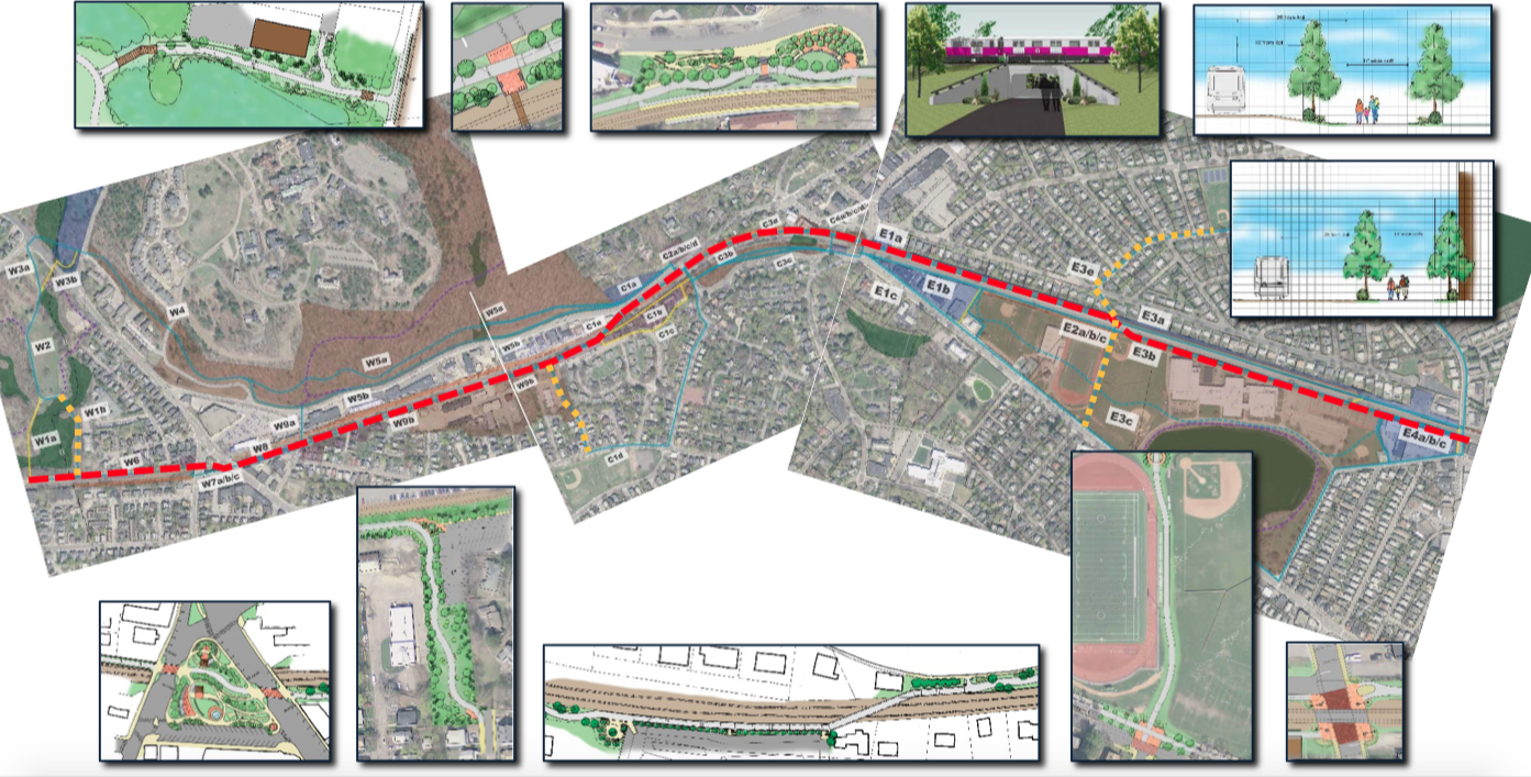
Phase 1 of the Community Path will extend from the end of the existing Fitchburg Cutoff Path at Brighton Street on the Cambridge line through Belmont Center Station and to the existing Clark Street Pedestrian Bridge at Pleasant Street, and will include a spur at Alexander Avenue connecting the Winn Brook neighborhood to the Belmont High School and Middle School and Concord Avenue via a tunnel under the MBTA Fitchburg Line. 

Phase 1 of the Belmont Community Path has been determined by the state to be eligible for Transportation Improvement Program (TIP) funding for construction and the submission of the 25 percent design plans to MassDOT (which occurred on Nov. 3) is an important milestone towards securing TIP funding and generally moving the project toward completion. 

During the presentation, the design consultant will walk through the 25 percent design plans, discuss updates to the plans since the draft set of plans were presented in July 2020, discuss next steps for the project (including further opportunities for public input), and answer questions and take comments and feedback on the plans. 

The 25 percent design plans are posted for review at https://belmontcommunitypath.com/2021/11/25-submission-public-information-meeting/. For those who wish to watch the presentation again or for the first time, the event will be recorded by the Belmont Media Center.

Community Path Public Meeting Set For Thursday, July 16, 7PM

Photo: The community path in Belmont

The Belmont Community Path Project Committee is holding a remote public information meeting Thursday, July 16 with the the town’s engineering consultant Nitsch Engineering to go over Phase 1 of the Community Path project.

The meeting will be a presentation by the Boston-based engineering firm regarding the draft 25 percent design plans for the community path, and an opportunity to ask questions and provide feedback on the draft design.

The presentation will include the path from the Clark Street bridge to the Belmont/Cambridge line and the proposed pedestrian tunnel under the MBTA commuter rail tracks at Alexander Avenue.

The CPPC also encourages you to review the draft design plans, which are posted and available for download on Nitsch’s project website at https://belmontcommunitypath.com/project-updates/

This important milestone helps the project advance and remain on track to receive funding as part of the state’s Transportation Improvement Program (TIP).  

The meeting will be held at 7 p.m., and you can find the agenda and Zoom sign-in information is available on the town’s website: https://www.belmont-ma.gov/sites/g/files/vyhlif2801/f/agendas/2020-07-16_community_path_project_1.pdf

HOW TO ACCESS THE MEETING

FOR PARTICIPANTS: The Community Path Project Committee meeting will start at 7:00 P.M. and you may join the meeting remotely starting at 6:50 P.M.  The meeting will also be broadcast and recorded by the Belmont Media Center.

LINK TO VIRTUAL MEETING:

TO PROVIDE YOUR FEEDBACK:

Enter your Full Name under participant if you would like to provide comments and feedback (only those with a name entered will be allowed to comment and provide feedback to the CPPC team)

When prompted by the meeting chair, you can “raise your hand” to be recognized by the meeting host

Comments will be limited by the Chair, shall be concise, and shall not repeat previous comments or questions presented by others before you Chair is not obligated to recognize all comments and may end comment period prior to your comment being heard


BY PHONE:

  • Dial-in: 1-929-205-6099
  • If you would like to provide comments: press *9 when prompted
  • When the host is ready for you, you will be called on by your phone number or name (when prompted always start by presenting your full name)

IF YOU ARE INTERESTED IN FOLLOWING ALONG ELSEWHERE:

  • Channel 8 on Comcast
  • Channel 28 or 2130 on Verizon

Original Meeting Notice MeetingDownload

Opinion: Five Facts That Need Examination To Determine Route For Community Path

Photo: 2014 map of the proposed community path. (Town of Belmont)

By Jarrod Goentzel and Phil Lawrence, co-founders, Friends of the Belmont Community Path

Dear Belmont Selectmen and Town Leaders on the Community Path Project Committee,

We appreciate the Board of Selectmen efforts to maintain momentum on the Belmont Community Path by making decisions to facilitate the next phase of design. We acknowledge that the 2-1 decision at the Feb. 25 meeting to recommend the route on the south side of the tracks from Brighton Street to Alexander Avenue followed careful deliberation and support from the Community Path Project Committee. Given that significant uncertainties remain for that section, we applaud the Selectmen’s decision to make this recommendation contingent on further due diligence of the southern route and to confirm the viability of Contingent Route number one on the north as a ready alternative. 

This period of due diligence is crucial. Selecting a route that ultimately cannot be designed or built due to insufficient town funding, environmental risk, broad public backlash, or other issues may cause Belmont to miss the federal funding opportunity. The Selectmen’s decision justifiably emphasized the feasibility study and its recommendation, which Pare Corporation did not change at the February 25 meeting based on recent information. The Selectmen also had to rely on personal judgment for issues where the study was incomplete. We suggest that the board to quickly assess additional evidence as it arises given the urgency of the design funding request to Town Meeting in May. 

As part of this due diligence, we review below the evidence regarding five key points discussed on Feb. 25 to identify areas where the feasibility study is incomplete and where the Selectmen’s judgment must be applied. 

1. The feasibility study recommendation is based on a slim 76-75 difference in score between the Recommended Route (South) and Contingent Route #1 (North).

It is important to note that during the Feb. 25 meeting, the score advantage for the southern route was mistakenly reported as 70-63 (which are actually the scores for the E3b and E3a sub-sections, respectively). The difference in composite score, which considers the alignment of all segments along the route as the basis of the route recommendation, is only 76-75. This extremely narrow margin justifies the BOS confirmation regarding the viability of readily switching to Contingent Route number one if due diligence raises concerns with the recommended route.

2. The feasibility study did not consider acquisition and environmental permitting costs for the Purecoat North/Crate Escape location that are required on the southern route for an easement.

The feasibility study only estimated costs for construction, operations, and maintenance, which would almost entirely be covered by federal funds. The study did not consider the costs for right-of-way acquisition or environmental permitting, both of which must be borne by the town. Discussion on Feb. 25 revealed incomplete information regarding the options and associated costs. The Selectmen wisely made their decision contingent on further due diligence.

3. The feasibility study did not assess environmental risks associated with the Purecoat North/Crate Escape location on the southern route.

Excavation for the path poses an extremely high risk for Chapter 21E environmental cleanup at the only location in Belmont tracked by the EPA as a toxic site. Belmont taxpayers deserve clarity on the potential costs and future risks associated with the recommended route and clarity on how the board would fund these incremental costs given the town’s financial constraints. The Selectmen wisely made their decision contingent on further due diligence. 

4. The feasibility study could not consider utilization of the Belmont High School property while under redesign.

The southern route runs through the high school campus, resulting in many positive aspects noted on Feb. 25. However, there are potential opportunity costs in using this property (e.g. lost field space or parking) and operational costs (e.g., security monitoring of a public pathway through the open campus). The Belmont School Committee has not yet taken a vote on this route. The Selectmen wisely incorporated approval by the School Committee as a contingency. 

5. The feasibility study recommendation and the recent Pare Corporation review of recent information ignore persistent public concern with the railroad crossing and state agency preference to avoid the railroad crossing.

The feasibility study analysis of the at grade Brighton Street crossing (segment E4a) did not distinguish a northern route crossing of the STREET ALONE from a southern route crossing of the STREET AND RAILROAD. This distinction is important for two reasons:

  • Public opinion: The study assumed double weights for all User Experience criteria based on clear public input. Recent public feedback centered on the difference in User Experience of a railroad crossing. With no distinction in scoring for E4, the feasibility study fails to incorporate persistent public concern with the at-grade railroad crossing.
  • The study assumed any MBTA rejection as a fatal flaw. Although he stopped short of rejecting the railroad crossing during the January 28 meeting, John (Jody) Ray from the MBTA stated: “the MBTA would always prefer that every crossing was a separated crossing, either below or above the tracks.” Michael Trepanier from MassDOT echoed this sentiment, saying “one fatality is always one too many”. With no distinction in scoring for that crossing, the feasibility study fails to incorporate the clear preference for the northern route Brighton Street crossing by the MBTA and MassDOT.

The Board of Selectmen’s judgment should consider that, given the feasibility study’s emphasis on User Experience and MBTA perspective, the composite score for the northern route would have scored higher and been recommended if there had been distinct scoring for the Brighton Street crossing.

The Selectmen recommended the southern route with contingencies regarding unknown right-of-way property issues and school preferences. The 60-day contingency period may not allow for proper due diligence with property owners to determine realistic acquisition costs or reasonable environmental risk assessment. The Board of Selectmen should only proceed with the design of the southern route if they can disseminate sufficient evidence to address the budgetary and environmental risks for Belmont residents and the safety concerns for future users whose federal taxes would build the path. If proper due diligence cannot be completed prior to the Town Meeting in May, then you should not stall momentum on the Belmont Community Path with further delays to gather more information. 

Meanwhile, there is no reason to delay. Evidence indicates that the contingent northern route is not only viable but also preferential when incorporating public and state agency opinion regarding the railroad crossing. With no right-of-way acquisition or potential EPA cleanup, the cost for Belmont is lower. We recommend that you reduce risks, lower costs, and avoid delays by promptly exercising the northern route contingency.

Note: To date, the Friends of the Belmont Community Path has focused on providing information to educate and encourage discourse among Belmont residents. Given the high priority for MassDOT to add this critical link in the Mass Central Rail Trail and use of federal taxpayer funds to build it, we plan to invite engagement with the wider community in advocating for a safe, off-road path.

Board Select South Route For Community Path … For Now

Photo: Pare’s Amy Archer (l) listening to Selectmen Chair Adam Dash. 

By a slim 2-1 margin, the Belmont Board of Selectmen voted to support placing a portion of a proposed community path from a new underpass at Alexander Avenue to Brighton Street along the south side of the commuter rail tracks, avoiding the residential neighborhood along Channing Road.

While it is the board’s preference, a south route is far from a slam dunk. Previous discussions with Purecoat North indicated the company was willing to sell the entire building – currently the home of the dog daycare facility Crate Escape – for upwards of $6 million for the entire structure, an amount Selectman Mark Paolillo called “unacceptable.”

The meeting was called to answer a simple question, said Chair Adam Dash: “If you know then what you know now, would you still support a south route for the path.” The quire was directed at Amy Archer, the consultant for the Pare Corporation which wrote the feasibility study of the entire community path which was presented in 2017.

Dash also said the selectmen have an increasingly tight time constraint on selecting a path as Town Meeting will have a $1 million Community Preservation Committee grant for design work to vote on and the town was preparing to seek state money for other work.

The board accepted Pare’s recommendation in which the path would run on the north side of the commuter rail line from Belmont Center to a proposed underpass at Alexander Avenue then proceeding along the south side to Brighton Street.

But the town and the board reopened the process in the fall of 2018 when word came from the MBTA and the MassDOT – who will determine which rail to trail projects around the state should receive funding – voiced considerable concern for the south route as it led commuters, pedestrians, and others to cross the rail tracks at an angle, which is a

At Monday’s meeting, Archer reiterated much of the initial findings which pointed out that as both the south and north options approached the Brighton intersection, they would encounter “pinch points” that will reduce the width the path to less than optimum ratios for safety and traveling.

Along the north side, there are 600 feet of path abutting property owned by FE French Construction, that would make it difficult for emergency vehicles to “literally open their doors” said Archer, if they were needed.

The southerly route would also meet a barrier of the Purecoat building of roughly 80 feet. But there was a solution, according to Archer; the acquisition by the town of a portion of the building, which would be removed or designed in a way to allow the necessary width for travel and first responders.

Archer said the study determined that “some negotiation” with the building owner on what they determined would be a “minor impact” to the structure. There was one catch to the building; it has been determined that soil is contaminated, which brings into play the state’s Superfund law, known as Chapter 21E, which describes the legal obligations of property owners and other potentially responsible parties when contamination is found which has its own potentially high price tag.

While running the path along Hittinger Street to Brighton to bypass the congestion point has been suggested and was in the feasibility study, the selectmen essentially rejected that proposal as well as taking the building through eminent domain laws.

Archer also noted that safety at Brighton Street intersection could be resolved with additional gates along the sidewalks. She noted that due to the future increased levels of the pedestrian, bike, and vehicular traffic on Brighton Avenue will require the intersection to be redesigned for increased safety and effective traveling whether the path is built or not.

After the presentation, Dash asked if Archer’s decision from 2017 to recommend the southern route was still valid.

“The Pare team stands by that decision,” Archer told the board.

The board debated the “new” information, pondering whether to delay a decision or simply bite the bullet and make a final determination. In the end, the majority – Tom Caputo and Paolillo – settled on the compromise to select a southern route but only if and when “successful” negotiations with Purecoat.

“I can’t go against our expert consultants that were supported by the Community Path Advisory Committee,” said Paolillo. 

All Sides Prepping For Possible Ultimate Vote Monday On Community Path Route

Photo: The crossing at Brighton Street.

Paul Roberts is determined for one more time to rouse supporters to save the proposed community path as it nears a possible pivotal vote on its future course by the Belmont Board of Selectmen on Monday, Nov. 19.

“Once again into the breach, my friends,” declared Roberts, paraphrasing Shakespeare’s Henry V [“Once more unto the breach, dear friends”] on Twitter directing those to an impassioned post dated Sunday, Nov. 18 on his community-oriented Bogging Belmont site.

“[T]he Community Path faces a critical vote Monday evening by the Board of Selectmen and there’s at least a passing chance that staunch and sustained opposition to a common sense route along the Commuter Rail tracks by abutters on Channing Road will force a decision that could doom the construction of the path,” warned Roberts.

Monday’s agenda calls for the selectmen to review the draft application for the path and “possible discussion and vote on the path route,” which has been the most contentious issue facing the bike/pedestrian trail for the past two decades.

(In a rather interesting detail from the agenda, the selectmen are setting aside a mere 10 minutes on the item, apparently not taking public comment or conduct a lengthy discussion on the matter before a possible vote.)

For supporters and opponents of a northern route, until late this summer, it appeared the route was all but finalized. The recommendation by the consultant, Pare Corp., which produced the path feasibility study earlier this year was for the trail to stay on the north side of the commuter rail tracks than transitioning to a southern path via a new pedestrian underpass near Alexander Street than travel along the southern side of the tracks to Brighton Street. From there, travelers would need to cross over the tracks to meet an existing bikeway leading to the Alewife MBTA station.

As supporters of what is called the “direct” path observed, two important changes have occurred since the study was released; the Massachusetts Department of Transportation (MassDOT) declared the underpass and the route from Belmont Center to the Cambridge line would not longer be seen as a single but two distinct projects, thus decoupling the funding for each project.

In addition, during discussions in August with town officials, selectmen and Belmont’s elected reps – State Sen. Will Brownsberger and State Rep. Dave Rogers – MBTA and MassDOT stated clearly they would seriously object to doling out upwards to 90 percent of the estimated $10 million construction cost of the path if the town’s plans continued to show people crossing the tracks at Brighton Street, deeming the action “unnecessarily unsafe,” according to MassDOT. It became clear, to path supporters, that only one viable option remained, the path staying on a northern side of the tracks.

In recent comments made at open meetings, it would appear the Selectmen are leaning heavily on the route hugging the commuter track’s north side s from Belmont Center to Brighton Street where it will hook up with the existing trail. Speaking in favor of a $1 million request from the Community Preservation Committee to pay for an engineering study of the path last week, Selectmen’s Chair Adam Dash said he envisioned the study to determine “what is required to make the northern route viable.”

“You’ll make the Selectmen’s ‘tough vote’ a lot easier by showing up to their hearing room Monday evening and voicing strong support for a compromise with the MBTA that will send the path along the North side of the tracks,” wrote Roberts.

Widely sent email claim “clandestine” actions

While Roberts is issuing the clarion call for supporters of the route, email correspondences from those opposing the northern route is asking residents for pushback to the selectmen’s likely rejection of the conclusions of the $200,000 feasibility study and the recommendation of the Community Path Implementation Advisory Committee, a town-committee created to develop to move forward the preferred Community Path route, after a heated meeting in October. 

In an email that mirrors several others being sent to residents, the letter is urging the selectmen to “endorse the exhaustive, fully transparent public process of both the [CPIAC] and the Pare Corporation.”

But the letter also trumpets its own call to arms, predicting that despite a large number of public meetings which residents allegedly preferred a southern route, there [are] “subtle suggestions” that the “selectmen will ignore the vote of the Committee and the Consultant in favor of some unclear, undisclosed reason.”

And the opponents have taken to pointing fingers specifically at State Sen. Brownsberger as being part and parcel in “clandestine discussions” with the MBTA and Mass DOT to promote alternative route that “both the Consultant and the CPIAC [said] have no merit.”

Along with a litany of past “problems” facing a northern route – environmental, needed easement, safety and possible legal action by a number of opponents – the letter also hones onto the premise the southern route is “a much more pleasant choice,” a point driven home by Belmont resident and developer Brian Burke at the October meeting of the CPIAC which ended in a bitterly divided vote.

It is Burke who is also promoting a “solution” to the need to cross the tracks at Brighton Street, predicting that a developer of a large commercial complex in Cambridge will build sometime in the next decade a pedestrian “bridge” over the commuter rail tracks allowing a southern route that will eventually connect with the current bike path to Alewife. 

What was noted at the October CPIAC meeting was Burke’s proposed solution has not passed further than the idea stage, as the development and bridge lacks a plan, an architect, a design or an OK from the MBTA and Mass DOT. 

A Quarter Century In the Making: Selectmen OK Recommended Community Path

Photo: Chris Leino, chair of the Community Path Implementation Advisory Committee.

After more than a quarter century since the idea was first introduced, the concept of a pedestrian and bike path running through the town took a major step forward as the Belmont Board of Selectmen voted unanimously to recommend a proposed $27.9 million route advanced by the five-member Community Path Implementation Advisory Committee at the board’s meeting held Monday, Dec. 4 at Town Hall. 

“In my view, this is really an amazing opportunity for Belmont. I think the community path if constructed would be a fantastic crown jewel for [the town] … and an amazing resource for Belmont and surrounding communities,” said Russell Leino, chair of the Advisory Committee which spent nearly three years both devising a process and then leading a year-long feasibility study which analyzed countless byways which would connect Belmont with a proposed 104-mile Mass Central Rail Trail running from Boston to Northampton.

“This is the path we need to endorse,” said Selectman Mark Paolillo, the committee’s liaison to the committee.

“It has gone through endless public meetings, a significant amount of input from all stakeholders … we have reached an answer that this board needs to support as a way forward,” said Paolillo. 

The unanimity of support from the town’s executives was the validation Leino was seeking as the project now moves forward to the critical funding phase. 

“I’m really excited because this is an important step forward for this project. [T]his vote is really the end of the beginning and now we need to move forward on both funding and construction,” Leino told the Belmontonian after the meeting.

The committee’s timeline for the roughly two-mile project includes funding for preliminary and final design in 2018, secure construction funds from state and federal agencies by 2019 and construction in 2020 and 2021.

The suggested route – running from the Waltham line outside Waverley Square and connecting to an existing travel path at the Cambridge border – was not a surprise as it was unveiled early in November during the final meeting of the 10-step feasibility study process run by PARE Consulting that spent more than a year conducting meetings, walking tours and public forums.

“Our consultant [PARE’s Amy Archer] did an incredible job. Her comprehensiveness and demeanor was exceptional and made the process successful because she was so good at engaging the public and listening to feedback and reacting to it in a calm and reflective way,” Leino told the Belmontonian. 

“There weren’t any knee-jerk decisions and the way the [recommended] path [was evaluated] was done in a very deliberative way by going over the criteria over and over again,” said Paolillo.

Selectman Adam Dash successfully proposed adding language in the declaration that will allow the board and town to “tweak” the recommended path when the project encounters “the inevitable” unexpected delays and possible disputes with landowners.

One area that will need to be negotiated is in Waverley Square where developer Joseph DiStefano is proposing constructing commercial space along Trapelo Road – to be revealed in the first quarter of 2018 – that will be adjacent to the bike path. DiStefano, who attended Monday’s meeting, said he is willing to begin discussions with the town on accommodating each other’s interest.

Three Routes Presented As Finalists for Belmont’s Community Path

Photo: Screenshot of the presentation from Pare Corp of one of the three top-ranking routes.

And now there are three.

After more than a half a year of analysis and study, the project management team conducting a feasibility study of a community path in Belmont presented to the public three possible routes that “scored” the highest.

“It was listening to the public and performing a great amount of analysis to come up with the highest ranking routes,” said Amy Archer of Pare Corp. who presented the top three trails to about 70 residents who braved a windy, rainy Wednesday night, April 26 to attend the ninth public meeting held by the firm.

Archer said Pare will return in June to present its recommended route to the Belmont Board of Selectmen which will either accept, reject or ask for more options. If it approves the route, the path could be completed by the fall of 2021.

The feasibility study was approved by Town Meeting in May 2016 to recommend a single route that would best serve residents and function as a segment of the Mass Central Rail Trail, a proposed 104-mile rail trail from Northampton to Boston that can be used by bicyclists, walkers, runners, and nature enthusiasts.

In the previous eight meetings, the study explored the dozens of segments of a possible route, graded each using criteria based on engineering standards, cost and comments from the community on what it wanted the path to be. The firm also rejected proposed spans determined “fatally flawed” due to high cost or chronic safety issues.

The three selected routes are similar regarding length – about two miles long – and in the “score” each achieved: the best option with a score of 76 would cost $27.9 million, the second and third – both with scores of 75 – are priced at $31.8 million and $25.1 million.

Each route travels along the northern edge of the commuter rail from Belmont Center to a proposed pedestrian tunnel at Alexandra Avenue where the paths then travel along the south side of the tracks adjacent Belmont High School.

Archer said diverting the paths to the southside rather than continue on land owned by the Belmont Community Forum takes the paths away from the majority of Channing Road homeowners who have long opposed a path adjacent to their property lines. The southside also has the option of not being “squeezed” at its end at the crossing at Brighton Street at the FE French Building.

A major issue confronting the path transversing the southside of the commuter tracks is it will be in the same location as the site of a proposed renovated/new Belmont High School and encroaches on the property of Crate Escape, the dog daycare business at the corner of Brighton.

Archer said talks are ongoing concerning the high school property. Also, the portion of the Crate Escape property that would be used by the path is the loading dock, which is not essential for the business.

The three paths are quite similar traveling from Waverley to Belmont Center, staying on the north side of Pleasant Street. The primary difference is how the trail transverses the Waverley Square Center and the commuter rail station. The higher cost options rely on covering the opening over the location and building walls to support the new construction as opposed to using ramps.

The relatively good news for Belmont is that Archer anticipates that the entire project will be “fully funded” by grants from the Massachusetts Department of Transportation and the MBTA, in part, to the popularity of rail trail projects and that Belmont is a significant segment connecting two sections of the Mass Central Rail Trail.

Any of the paths would most likely qualify for funding if the were direct route and one supported by local officials, noted Archer.

Money could also be coming from the MBTA, according to Community Path Implementation Advisory Committee member Vincent Stanton, as the path would solve a “big problem the MBTA is facing” with making the Waverley Station handicap compliant with the installation of a ramp system that would be part of the community path.

But  the town will be required to pony up “a substantial amount”  for the initial design stage which will cost just under 10 percent of the total cost or about $2 million, funding that could be obtained through grants from the town’s Community Preservation Act account, a request for capital funds, a state legislative earmark, private funds or any combination.

If the route is accepted, it will take nearly four years from the point the design of the path begins to a grand opening, with the final two years the construction phase.