Photo: Screenshot of the presentation from Pare Corp of one of the three top-ranking routes.
And now there are three.
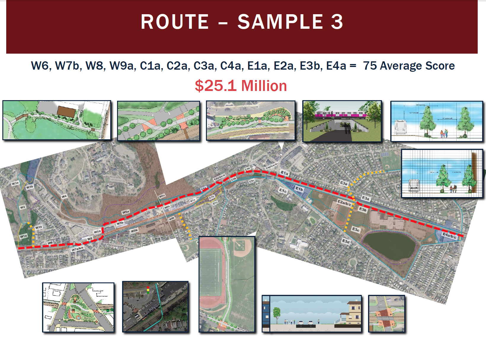
After more than a half a year of analysis and study, the project management team conducting a feasibility study of a community path in Belmont presented to the public three possible routes that “scored” the highest.
“It was listening to the public and performing a great amount of analysis to come up with the highest ranking routes,” said Amy Archer of Pare Corp. who presented the top three trails to about 70 residents who braved a windy, rainy Wednesday night, April 26 to attend the ninth public meeting held by the firm.
Archer said Pare will return in June to present its recommended route to the Belmont Board of Selectmen which will either accept, reject or ask for more options. If it approves the route, the path could be completed by the fall of 2021.
The feasibility study was approved by Town Meeting in May 2016 to recommend a single route that would best serve residents and function as a segment of the Mass Central Rail Trail, a proposed 104-mile rail trail from Northampton to Boston that can be used by bicyclists, walkers, runners, and nature enthusiasts.
In the previous eight meetings, the study explored the dozens of segments of a possible route, graded each using criteria based on engineering standards, cost and comments from the community on what it wanted the path to be. The firm also rejected proposed spans determined “fatally flawed” due to high cost or chronic safety issues.
The three selected routes are similar regarding length – about two miles long – and in the “score” each achieved: the best option with a score of 76 would cost $27.9 million, the second and third – both with scores of 75 – are priced at $31.8 million and $25.1 million.
Each route travels along the northern edge of the commuter rail from Belmont Center to a proposed pedestrian tunnel at Alexandra Avenue where the paths then travel along the south side of the tracks adjacent Belmont High School.
Archer said diverting the paths to the southside rather than continue on land owned by the Belmont Community Forum takes the paths away from the majority of Channing Road homeowners who have long opposed a path adjacent to their property lines. The southside also has the option of not being “squeezed” at its end at the crossing at Brighton Street at the FE French Building.
A major issue confronting the path transversing the southside of the commuter tracks is it will be in the same location as the site of a proposed renovated/new Belmont High School and encroaches on the property of Crate Escape, the dog daycare business at the corner of Brighton.
Archer said talks are ongoing concerning the high school property. Also, the portion of the Crate Escape property that would be used by the path is the loading dock, which is not essential for the business.
The three paths are quite similar traveling from Waverley to Belmont Center, staying on the north side of Pleasant Street. The primary difference is how the trail transverses the Waverley Square Center and the commuter rail station. The higher cost options rely on covering the opening over the location and building walls to support the new construction as opposed to using ramps.
The relatively good news for Belmont is that Archer anticipates that the entire project will be “fully funded” by grants from the Massachusetts Department of Transportation and the MBTA, in part, to the popularity of rail trail projects and that Belmont is a significant segment connecting two sections of the Mass Central Rail Trail.
Any of the paths would most likely qualify for funding if the were direct route and one supported by local officials, noted Archer.
Money could also be coming from the MBTA, according to Community Path Implementation Advisory Committee member Vincent Stanton, as the path would solve a “big problem the MBTA is facing” with making the Waverley Station handicap compliant with the installation of a ramp system that would be part of the community path.
But the town will be required to pony up “a substantial amount” for the initial design stage which will cost just under 10 percent of the total cost or about $2 million, funding that could be obtained through grants from the town’s Community Preservation Act account, a request for capital funds, a state legislative earmark, private funds or any combination.
If the route is accepted, it will take nearly four years from the point the design of the path begins to a grand opening, with the final two years the construction phase.


Leave a Review or Comment