With Temp Near 100, Belmont Under Heat, Air Quality Warnings Wednesday

Photo: It’s a hot one Wednesday.

Usually, when Belmont is placed under a weather advisory, the town is expecting a storm to bring a foot or two of snow.

But on this Wednesday, Aug. 26, the “Town of Homes” will experience a second day of just plain hot.

As of 5 a.m., the National Weather Service in Norton issued an advisory as the region suffers under the most oppressive heat events of the year. The service placed most of eastern Massachusetts under an Excessive Heat Warning until 9 p.m. tonight. An Excessive Heat Warning means that a prolonged period of dangerously hot temperatures will occur. The combination of hot temperatures and high humidity will combine to create a dangerous situation in which heat illnesses are likely.

While the Weather Underground Payson Park weather station is forecasting a high of 95 degrees F, the heat index temperature – which takes into effect humidity in the calculation of how hot it is – will exceed 100 degrees this afternoon. 

The heat and humidity may cause heat stress during outdoor exertion or extended exposure, according to the NWS. Take extra precautions, if you work or spend time outside. When possible, reschedule strenuous activities to early morning or evening. Drink plenty of fluids, stay in an air-conditioned room, stay out of the sunshine, and check up on relatives and neighbors.

The Massachusetts Department of Environmental Protection has issued an Air Quality Action Day for Ground-Level Ozone, in effect from 11 a.m. to 11 p.m. An Air Quality Action day means that Ground Level Ozone concentrations within the region may approach or exceed unhealthy standards for sensitive groups including people with heart or lung disease such as asthma, older adults, children, teenagers, and people who are active outdoors. People with lung disease are at greater risk from exposure to ozone, while people with either lung disease or heart disease are at greater risk from exposure to particle pollution.

People in sensitive groups should reduce prolonged or heavy outdoor exertion; take more breaks and do less intense activities, and follow asthma action plans and keep quick-relief medicine handy. Watch for symptoms such as coughing or shortness of breath.
Belmont Shuts Down Thursday As Major Storm Arrives – But Trash Will Be Picked Up!

Photo: It’s coming!

Belmont will effectively shut down for the entirety of Thursday, Jan. 4, as the region will be hit by what some are calling a “bomb cyclone” or what most New Englanders still describe as a good ol’ Nor’easter.

The National Weather Service issued a Winter Storm Warning at 4:29 p.m. Wednesday, Jan. 3 that will be in effect from 1 a.m. Thursday to 1 a.m. Friday, Jan. 5. Snow will be heavy and winds will be steady at 20 mph with gusts reaching 40 mph. 

In terms of timeline, the snow will begin in the early morning hours of Thursday, continuing throughout the day. The worst of the storm will occur from noon until 6 p.m. when most of the snow will be on the ground.

How much? Depending on what media source you decide is credible predicting the weather, from 8-12 inches (Globe), 9-13 from the NWS or 18 inches (Patch).

And Belmont will be shut down tight for the “bomb”: 

  • Belmont Public Schools will be closed on Thursday.
  • Town buildings will be closed.
  • There will be a SNOW EMERGENCY PARKING BAN in Belmont on all roadways and Municipal parking lots including schools effective at 6 a.m. on Thursday, Jan. 4 until further notice. All vehicles parked in violation of the ban will be towed at the owner’s expense.
  • Belmont Public Library and the Benton Library will be closed
  • Trash and recycling will be picked up as scheduled on Thursday.

If residents have any questions, they should call the snow emergency hotline at 617-993-2698.  

High Winds, Hazardous Weather for Belmont Into Monday

Photo: Wind damage in Belmont, winter of 2016.

Belmont has been placed under a High Wind Warning from 6 p.m. Sunday, Oct. 29 to 6 a.m. Monday, Oct. 30.

The town and region will also be impacted by moderate to heavy rain producing between one to three inches of rainfall into early Monday morning, according to the latest news release by the service at 4:34 a.m. Sunday, Oct. 29 that also issued a Hazardous Weather Outlook for eastern Massachusetts.

Winds from the Southeast will be steady at 30 to 40 mph with gusts up to 65 mph through early Monday morning. The area can expect tree damage and down power lines due to fall limbs from trees. The NWS advises homeowners to take action to secure loose outdoor objects.

If the power goes out during the storm, call the Belmont Light outage line at 617-993-2800.

Low lying areas and streets that typically became waterlogged in Belmont will likely to flood resulting in localized urban flooding due to the heavy rain.

Early Warning: Storm Watch Already Issued For Tuesday’s Nor’easter

Photo: Winter Storm Watch issued for Tuesday’s Nor’easter.

It is more than 24 hours away but the National Weather Service has already issued a Winter Storm Watch for Belmont and the region for a classic Nor’easter that will arrive late Monday night and remain in the area for 24 hours.

Issued at 9:58 p.m. on Saturday, March 11, the NWS statement warns of heavy snow with accumulations of greater than six inches of snow will occur between the night hours of Monday, March 13 and throughout Tuesday, March 14. 

“The heavy snow will make many roads impassable. In addition, strong winds may lead to blowing and drifting snow, reduced visibility, and power outages,” reads the report.  

Winds will come out of the northeast 20 to 30 mph with gusts 40 to 50 mph.

A Winter Storm Watch means there is a potential for significant snow, sleet, or ice accumulations that may impact travel. Continue to monitor the latest forecasts. Be prepared to modify travel plans should winter weather develop.

Snow Again: Gusty Blizzard on Tap for Sunday Evening/Monday

Photo: Snow? Again?

The National Weather Service Sunday morning, Feb. 12, has issued the second winter storm warning in three days lasting until 7 p.m., Monday, Feb. 13.

The storm will be the second nor’easter since Friday’s whiteout which brought nine inches of snow over eight hours on Thursday, Feb. 9. 

The NWS is predicting snow between 10 to 14 inches over 36 hours beginning at 1 p.m., Sunday. 

The NWS forecast includes:

  • Heavy snow with accumulations of 4 to 12 inches.
  • Steady snow will begin around noon Sunday then heavy in the afternoon into Monday, ending in the late afternoon Monday.
  • Hazardous travel due to snow covered roads and reduced visibilities. Blowing and drifting snow is possible.
  • Winds will be out of the west 10 to 20 mph with gusts up to 50 mph.

February Nor’easter Blowing into Belmont Thursday AM, Lasting All Day

Photo: You know the drill.

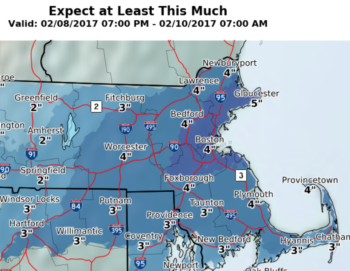
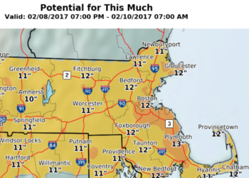
A good ol’ Nor’easter will dump between four inches to a foot of snow in Belmont all-day Thursday, Feb. 9.

At 10 a.m. today, Wednesday, Feb. 8, the National Weather Service issued a Winter Storm Warning for eastern Massachusetts including Belmont from 6 a.m. Thursday, Feb. 9 to midnight, Friday, Feb. 10.

Here are the details from the NSW:

  • Heavy snow with accumulations between 4 to 12 inches.
  • Snow will begin early Thursday morning and last through much of the day before ending Thursday evening. 
  • Snow could fall heavy at times and impact both the morning and evening commutes.
  • Hazardous travel due to snow covered roads and poor visibilities. Blowing and drifting snow is possible.
  • Winds will be out of the North 20 to 30 mph with gusts up to 50 mph.

The NWS provided a pair of maps relating to the amount of snow that we can expect to be shoveling. See below. 

screen-shot-2017-02-08-at-1-26-25-pm screen-shot-2017-02-08-at-1-26-51-pm

Belmont Under Winter Weather Advisory; 3″ to 6″ of Snow Expected

Photo: Snow’s a-coming.

Well, at least it was a nice morning.

The National Weather Service in Taunton issued a winter weather advisory in effect from noon today, Tuesday, Jan. 31 to 4 a.m., Wednesday, Feb. 1 as the service is predicting up to half a foot of snow blanketing Belmont and most of the state when the storm ends around noon Wednesday.

Snow is expected to develop in the afternoon starting off as a brief period of heavy snow in early evening, falling at an inch an hour. The snow will taper off overnight. 

As of 10 a.m., Tuesday, Belmont has not issued a snow emergency. 

The storm will result in hazardous travel conditions 

Belmont Under Wind Advisory til’ Tuesday, Outages Possible

Photo: Trees could be coming down due to high winds.

The National Weather Service has issued a wind advisory for Belmont as a power storm that swept through the Southeast US will be blowing through New England beginning Monday afternoon, Jan. 23, 

The advisory, which was issued at 5:11 p.m. Monday, will remain in effect until 7 a.m. Tuesday.

Steady winds from the northeast between 20 mph and 30 mph with gusts up to 55 mph will occur between 10 p.m. to 4 a.m.

“These winds will be capable of downing a few trees and may result in isolated power outages … [and] may also cause localized property damage,” said the NWS advisory.

Belmont Light customers who are experiencing an outage should call Belmont Light’s emergency line at 617-993-2800

Belmont Under Wind Advisory Through Friday AM; Increased Chance of Outages

Photo: Trees could come falling down.

The National Weather Service has issued a wind advisory for Belmont and Eastern Massachusetts from 7 p.m. Thursday, Dec. 29 to 6 a.m. Friday, Dec. 30, with near gale force winds buffeting the region and creating conditions that could lead to electrical outages.

The NWS is forecasting sustained winds out of the West between 10 to 20 mph with gusts reaching 50 mph with the strongest winds coming between 7 p.m. and 3 a.m.

Gusts have the potential of downing trees and large limbs possibly causing isolated power outages.

While a major winter storm is expected to dump up to a foot of snow in the western part of Massachusetts into Friday morning, Belmont and the Boston region should only see a few inches of the white stuff before precipitation ends late Thursday night.

Below are telephone numbers to keep at the ready during the storm:

Belmont Light (to report outages): 617-993-2800.

The Town of Belmont SNOW EMERGENCY HOTLINE: (617) 993-2698.

Unless it is an emergency, do not call 911.


Expect Possible Severe Weather For Most Of Monday Afternoon

Photo: Boomers are heading this way. 

The National Weather Service in Taunton has issued a “Special Weather Statement” this morning that most of New England, including Belmont, could see severe thunderstorms arriving sometime this afternoon.

The report released at 3:35 a.m., Monday, July 18, stated a line of thunderstorms is expected to cross southern New England between 2 p.m. and 8 p.m. that “may bring damaging winds, hail, torrential rainfall and frequent lightning.”

The one saving grace for the Boston region is that the greatest risk for the stormy weather is western and north central Massachusetts and northern Connecticut. 

The NWS advises anyone with outdoor plans to “keep an eye to the sky and get indoors when you first hear thunder.”

“Wait at least 30 minutes until the storm passes to resume outdoor activities.”