Belmont Police Issues Snow Emergency Parking Ban Beginning Late Saturday As Winter Storm Watch Is Declared

Photo: Parking ban begins 11:45 p.m. Saturday, Jan. 6.

In an attempt to get ahead of the first nor’easter of the winter, the Belmont Police Department has announced a Snow Emergency Parking Ban on all town roadways, as well as in municipal parking lots and Belmont Public School parking lots, effective Saturday Jan. 6, at 11:45 p.m. and continuing until further notice. Any vehicle parked in violation of the ban will be towed at the owner’s expense.

The ban comes as the Boston office of the National Weather Service issued a Winter Storm Watch from Saturday afternoon through late Sunday night for eastern Massachusetts including Belmont.

“Heavy snow possible. Total snow accumulations of 3 to 8 inches possible. Winds could gust as high as 35 mph,” according to the NWS which released the warning at 4:34 p.m. on Friday, Jan. 5.

Town officials are reminding residents the town’s residential snow removal bylaw requires sidewalks along residential property to be cleared of snow and ice by 8 p.m. the day after a storm ends. Snow and ice should be cleared or treated from sidewalks to a width of at least 36 inches.

Residents should go to the town’s web site for further information regarding winter weather and the town’s snow removal bylaw .
There It Blows: Gale Forced Winds/Snow This Week Could Cause Outages

Photo: Wind and snow over the next three days

Gale forced winds up to 70 mph will storm through eastern Massachusetts and Belmont from Monday, March 13 to Wednesday, March 15 with the potential of down electrical wires causing outages during the week.

In a press release issued at 3:35 p.m. on Sunday, March 12, the National Weather Service said a Winter Storm Watch will be in effect from Monday evening through Wednesday morning.

The storm will start as rain, changing to snow Tuesday morning, accumulating into Tuesday night. The late day Tuesday commute will likely be impacted with snow covered roads and low visibility,” said the NWS.

“Travel could be difficult. Heavy wet snow combined with gusty winds could bring down tree branches and result in power outages,” said the report.

If the lights go out, call Belmont Light‘s outage number: 617-993-2800

Or text an outage to 617-993-6006 with all the necessary information: Name, address, outage information. When reporting an outage Belmont Light encourage customers to send photos of any damages, infrastructure issues, and general community engagement. But do it safely.

Belmont Light also has an outage map online where customers and residents stay informed on the extent of the outage.

With High Wind Warning in Effect, Widespread Outages In the Mix

Photo: Blustery, it is

Power up your computers and phones because “the weather outside is frightful” and you may loss your power due to a storm that’s bringing strong, damaging winds through Christmas eve.

At 3:30 a.m. Friday, Dec. 23, the National Weather Service issued a High Wind Warning for Belmont and all of eastern Massachusetts that will remain in effect until 7 a.m., Christmas Eve, Saturday, Dec. 24.

The wind will be coming in from the South at 20 to 30 mph with gusts up to 60 mph, according to the NWS advisory. Isolated gusts up to 65 mph will occur this morning along the coastline.

Damaging winds will blow down trees and power lines, toss trash and recycling bins to parts unknown and will defeat any and every umbrella. “Widespread power outages are expected,” the NWS noted. Travel will be difficult, especially for high profile vehicles such as 18 wheel and box trucks as well as SUVs.

If your power does go out, you can call the Belmont Light outage number at (617) 993-2800. You can see real time outage locations at the Belmont Light Service map.

Breaking: Belmont, Region Under Flood Watch ’til 5 PM Tuesday, Sept. 6

Photo: Flood Watch in effect in Belmont

The National Weather Service has issued a Flood Watch for Belmont and communities in eastern Massachusetts that will last until 5 p.m. on Tuesday, Sept. 6. Rainfall amounts of three to five inches are expected over much of southern New England with localized amounts of five to seven inches or more.

During this period, flooding caused by excessive rainfall continues to be possible.

Earlier Monday, the NWS issued a Flash Flood Warning for most of northern Massachusetts before downgrading it at 10:47 a.m. on Monday, Sept. 5. A Flash Flood Warning is issued when a flash flood is imminent or occurring. If you are in a flood prone area move immediately to high ground. A Flood Watch is issued when conditions are favorable for flooding. It does not mean flooding will occur, but it is possible.

Flooding of small creeks and streams, urban areas, highways, streets and underpasses as well as
other poor drainage and low-lying areas is possible and citizens should stay vigilant.

Locations that will experience flash flooding include Belmont, Cambridge, Newton, Somerville, Waltham, Arlington, Watertown, Lexington, Tewksbury, North Andover, Melrose and Saugus.

The NWS warns drivers to “Turn around, don’t drown” when encountering flooded roads. Most flood
deaths occur in vehicles. Be especially cautious in early morning hours when it is harder to recognize the
dangers of flooding.


No Surprise Here: Snow Emergency Parking Ban Declared Beginning Just Before Midnight On Friday, Jan. 28

Photo: It could be the big one.

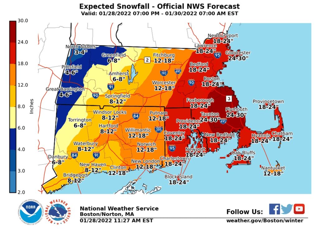
With a (maybe-not-so) historic blizzard waiting on the horizon, Belmont has declared a snow emergency parking ban on all roadways as well as parking in municipal lots and Belmont Public School parking lots starting at 11:45 p.m., Friday, Jan. 28 and continuing until the town sees fit lifting it.

All vehicles parked in violation of the ban will be towed at the owner’s expense. 

The latest update from the National Weather Service at 3:22 p.m. on Friday calls for blizzard conditions for 24 hours starting at midnight, Jan. 29 with total snow accumulations of 18 to 24 inches accompanied with winds gusting as high as 60 mph. Some meteorologists this afternoon have scaled back their earlier assumptions, with one dragging it back to 12 to 16 inches.

Travel could be extremely difficult to impossible as the storm enters Saturday afternoon.

While the snow will be light and fluffy north of the Massachusetts Turnpike, blizzard winds could cause branches to land on electric wires and cut power. For anyone who losses electricity during the blizzard should call the Belmont Light Outage line at 617-993-2800. You can also follow where the lights are out by visiting the outage map at https://www.belmontlight.com/service-map/

All town, school and library activities have been cancelled for both Saturday and Sunday. 

The Department of Public Works asks residents to please exercise caution when walking on or near roadways as visibility for plow truck operators will be significantly reduced.

The

Winter Storm Warning For Belmont: 5″ to 8″ Of The White Stuff On Friday

Photo:

Belmont and communities inside the Route 128 corridor are under a Winter Storm Warning as between five to eight inches of snow is expected on Friday, Jan. 7.

The warning, issued at 3:24 a.m., Thursday, Jan. 6 by the National Weather Service, forecasts heavy snow from 1 a.m. to 7 p.m. in portions of eastern and southeastern Massachusetts and Rhode Island.

Travel could be very difficult, warned the service, as hazardous conditions could impact the morning or evening commute.

“If you must travel, keep an extra flashlight, food, and water in your vehicle in case of an emergency,” reads the press release. The latest road conditions for the state can be obtained by calling 511.

Winter Advisory; Icy Roads and Sidewalks For Tuesday’s Morning Commute

Photo: Ice coated roadways, sidewalks and stairs expected Monday night and into Tuesday morning

The National Weather Service in Boston issued a Winter Weather Advisory from 7 p.m. Monday, Dec. 27 until 10 a.m. on Tuesday, Dec. 28 warning of freezing rain with ice accumulations of up to one-tenth of an inch of a light glaze coating sidewalks and roadways in Belmont and throughout Massachusetts.

The NWS calls for residents to plan plan on slippery road conditions that could impact the Tuesday morning commute.

“Slow down and use caution while traveling,” the service advises.

Belmont, Middlesex County Under Tornado Warning Until 1:45 PM Thursday

Photo: Tornado warning in Belmont

A Tornado Warning has been issued for Belmont and other communities in East central Middlesex County until 1:45 p.m. by the National Weather Service in Boston.

The NWS is advising everyone to take cover now. Move to a basement or an interior room on the lowest floor of a sturdy building. Avoid windows. If you are outdoors, in a mobile home, or in a vehicle, move to the closest substantial shelter and protect yourself from flying debris.

Flying debris will be dangerous to those caught without shelter. Mobile homes will be damaged or destroyed. Damage to roofs, windows, and vehicles will occur. Tree damage is likely.

Snow Emergency 2.0: Second Parking Ban In A Week Starts Noon, Sunday

Photo: A second nor’easter in the past week is heading towards Belmont.

For the second time in a week, the town of Belmont has issued a Snow Emergency Parking Ban due to what the National Weather Service is calling a “quick hitting” snow storm that could produce up to an inch of snow an hour at the height of the nor’easter.

The ban begins at noon, Sunday, Feb. 7 and will last until further notice. Parking is prohibited on roadways, municipal and school parking lots. Vehicles in violation may be towed.

The NWS Boston station, which issued a Winter Weather Advisory, reported the winter storm will bring accumulating snow to much of southern New England Sunday. Snowfall may be heavy at times and cause hazardous travel.

The latest information as of 3:34 a.m. Sunday has the snow beginning before noon and lasting until 10 p.m. to midnight with up to six inches of snow on the way.

Belmont Under Winter Storm Warning ‘Til Tuesday Afternoon

Photo: Snow storm heading Belmont’s way

Upwards to a foot of snow is set to fall on Belmont and the rest of Massachusetts beginning Monday, Feb. 1 as the state has been placed under a winter storm warning by the National Weather Service.

Residents should anticipate the town issuing a snow emergency parking ban for all roadways and municipal and Belmont Public School parking lots.

Issued at 3:37 p.m., Sunday, Jan. 31, the Service’s Boston office is predicting heavy snow of between 7 to 15 inches with wind gusts as high as 45 mph. The storm is anticipated to begin 10 a.m. Monday with the heaviest precipitation Monday afternoon and evening. It’s expected to pass through the region Tuesday after noon.

Traveling will be “very difficult to impossible” in the many parts of the state as hazardous conditions could impact the morning or evening commute, said the Service. Gusty winds could bring down tree branches and may increase the risk for power outages, in addition to the gusty northeast winds.

If you are experiencing an outage, call Belmont Light’s Outage hotline at 617-993-2800. Do not call 911.