PHOTOS: A Blizzard Walk in Belmont

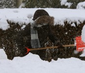
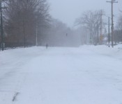
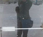
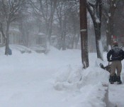
The cold and wind knocked the breathe right out of anyone who stepped outside today as the Blizzard of 2015 settled over Belmont.

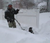
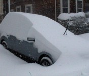
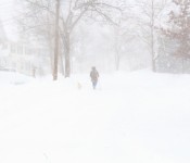
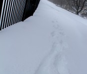
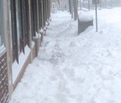
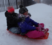
With wind chills below zero and the difficulty of several feet of snow on the ground, whether one was beginning to shovel out front steps, walking the dog, heading for some sledding or just to take some time out of the house was a challenge.

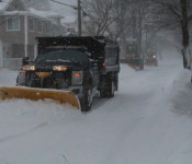
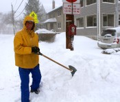
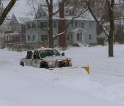
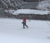
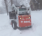
The Eastern Massachusetts driving ban – which was being ignored by some just after noon – allowed walkers to stride (albeit carefully) down main streets such as Trapelo Road without the hassle of thousands of vehicles. Town equipment and private contractors were mostly successful to keep the main thoroughfares open but most side streets appeared untouched for hours. In many areas, contractors lugging snowblowers had already begun throwing snow from sidewalks and driveways.

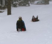
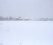
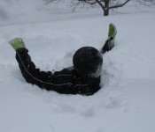
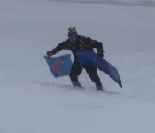
On Payson Road, the north side of the Cambridge Reservoir had drifts up to four-feet deep, while on the south side, hardy souls both young and not-so-young wanted to take the first ride down the slope.


All Hands on Deck: Belmont DPW Throwing Everything into Blizzard

Jay Marcotte, Belmont’s newly-installed Director of Public Works, said this past Saturday’s snowfall “was a chance for the department to shake the rust off” its response in preparing and handling the inevitable task for any New England town’s DPW in clearing roads of the white stuff.

“It was only four-and-a-half inches in Belmont and we didn’t have a single resident’s call on our snow hotline,” said Marcotte as he introduced himself to the Belmont Board of Selectmen on Monday morning, Jan. 26.

The Belmont Department of Public Work’s Snow Emergency Hotline: 617-993-2698.

But as a potentially historic nor’easter was barreling towards the region and Belmont, Marcotte – who took over the reins of the department from the retiring Peter Castanino – wasn’t expecting his department to have as easy a go of it as three days previous.

“I suspect the hotline will have a few more calls,” he said, with a smile.

To handle the blizzard, Marcotte and Highway Division Manager Michael Santoro will be marshaling all the division’s assets as well as an army of private contractors to keep at least the main thoroughfares passable for first responders and other essential vehicles.

“It’s all hands on deck,” said Marcotte.

The Highway Division has put out 20 pieces of town-owned equipment clearing roads, including dump trucks, pickups and spreaders beginning at 6 p.m. on Monday. In addition, 37 vehicles from private contractors will be hitting the streets during the height of the storm and afterwards, said Marcotte.

In addition, a tree service is on standby to remove branches and trees that could topple during the storm and heavy equipment from James W. Flett Company and FE French Construction are ready “just in case we need them,” said Marcotte.

The DPW’s primary goal will be “to keep the main drags plowed and treated so medical and other emergency services” can get to their destinations, said Marcotte.

Plowing and treating of secondary and side roads are accomplished “as soon as the department can get to them, he said.

The planning, for tackling a storm “, is the same whether it is 2-inches or 24-inches,” said Marcotte.

“We treat [storms] accordingly to what is expected but we make sure we have a plan ready to go,” he said.


Blanketed Belmont: All-Day Blizzard Finally Winding Down Tonight

A blizzard warning remains in effect in Belmont and all of eastern Massachusetts until 1 a.m., Wednesday, Jan. 28, as the town and region have literally been shut down as a historic Nor’easter delivers nearly two feet of snow and gale force winds to New England.

In its latest report issued at 4:34 a.m. today, Tuesday, Jan. 27, the National Weather Service in Taunton said the region can expect heavy snow this morning at the rate of 2 to 3 inches an hour accompanied by strong and damaging winds – from the north at a sustained 25 to 35 mph with gusts to 65 mph – resulting in white-out/blizzard conditions with near zero visibility.

“Travel will be impossible and life threatening across the entire region. Also snow may be wet enough to result in downed tree limbs and power outages in addition to the winds,” said the NWS.

Snow totals have been reduced slightly as the NWS is predicting 15 to 25 inches of snow, a dip from earlier predictions of 20 to 30 inches. But the strong winds will cause snow drifts of up to four feet in some locations.

But there is light at the end of the tunnel: the NWS said the worst of the storm will be through this afternoon then diminishing later tonight with the winds slowing beginning in the early afternoon.

Belmont Declares Parking Ban Beginning at 6PM Monday

With a Nor’easter ready to blow into town, Belmont’s Department of Public Works has declared a town-wide parking ban beginning at 6 p.m., Monday, Jan. 26. 

During the ban, NO ON-STREET PARKING is allowed on Belmont street to allow the Highway Division to do a better job clearing the roadways. In addition, no parking is allowed in the town’s three municipal lots – Belmont Center, Cushing and Waverley squares – or in the six public school parking lots.

Vehicles that are in violation of the parking ban will be towed.

The ban will be lifted when the DPW determines Belmont roads are passable.

No Trash and Recycling Collection Tuesday due to Blizzard

You know Belmont is taking this storm seriously as for the first time in decades, a snow storm will halt curb-side trash collection. But only for one day.

“Due to the impending snow storm there will not be any trash or recycling collection on Tuesday, Jan. 27.  Trash and recycling collection will resume on Wednesday, Jan. 28.  Collection for all days remaining this week will be delayed one day.”

The Three Belmont Phone Numbers You’ll Need During the Nor’easter

While the likelihood the worst to happen to most people during this coming Nor’easter is battling over what to watch on Netflix, there are specific phone numbers all Belmont residents should keep close “just in case” something beyond the norm does happen.

Of course, for a true emergency in which health and safety are threatened, call 911.

  1. The Belmont Department of Public Work’s Snow Emergency Hotline: 617-993-2698.
  2. To report a power outage to Belmont Light, call 617-993-2800. Do not call 911.
  3. After the storm has ended, if you have a question about street cleaning and other issues, call the Belmont Public Works Highway Division at 617-993-2600.

Latest Nor’easter Update: Yup, A Big, Bad Blizzard Heading to Belmont

Batten down the hatches, Belmont. A blizzard’s heading’ this way.

The latest information from the National Weather Service, released at 3:53 a.m. this morning, Monday, Jan. 26, is predicting snow accumulations of “around 20 to 30 inches with locally higher amounts.” This nor’easter could match the 27.1 inches of snow that hit Boston in the famous Northeastern United States blizzard of 1978. 

“Those venturing outdoors may become lost or disoriented … so persons in the warning area are advised to stay indoors,” warned the NWS as it issued a Blizzard Watch for the eastern part of the state and region.

While the storm is expected to begin late today and linger into early Wednesday, the worst of the storm will be tonight, Monday, Jan. 26 through Tuesday afternoon, Jan. 27.

And once it starts, the heavy snow – falling Tuesday morning up to 2 to 4 inches an hour – and strong winds will result in white-out/blizzard conditions with near zero visibility.

Winds will be out of the north-northeast at 15 to 25 mph with gusts around 65 to 75 mph with the worst of the winds coming late tonight, Monday, into Tuesday.

“Travel will be impossible and life threatening across the entire region. Also snow may be wet enough to result in downed tree limbs and power outages in addition to the winds,” reported the NWS.

The National Weather Service is advising resident that all unnecessary travel is discouraged beginning after Monday’s commuter rush to allow people already on the road to safely reach their destination before the heavy snow begins and to allow snow removal equipment to begin to clear roads.

Historic Nor’easter Blowing into Belmont From Monday Evening Through Tuesday Night

A massive Nor’easter will blow into Belmont and the region beginning Monday night and lasting for 24 hours, bringing up to two feet of snow along with blizzard conditions that will make travel dangerous.

“This has the potential to be a historic storm,” noted the National Weather Service in Taunton which issued the Blizzard Warning at 12:34 p.m. on Sunday, Jan. 25.

The NWS forecast calls for continuous heavy snow and strong winds between 20-to-30 mph with gusts of up to 60 mph to produce whiteout conditions with considerable blowing and drifting snow with the worst of the storm occurring between Monday night, Jan. 26 through Tuesday afternoon, Jan. 27.

The snow may be wet enough to result in some downed tree limbs and power outages. Travel may become impossible and life threatening across the entire region as temperatures will stay in the low 20s.